
Space Information Map (SIM)
The SIM (Space Information Map)
The Space Information Map (SIM) is a resource that brings together building, geographic, and spatial data into one map interface for campus stakeholders. It is a map that has our updated floor plans for campus buildings, and connects that with our latest space data from our space management system. The map links out to other valuable resources including our Floorplan PDF Sharepoint Site as well as our Space Optimization Tableau Site that has access to space reports. The creation of this tool is a part of our mission to liberate our spatial data on campus and get it into more people's hands to make informed decisions about space on campus.
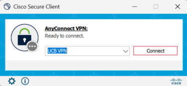
If you have access to this resource, please be aware that you will need to be connected to the CU VPN to access it even if on campus:
Click 'Sign In' at the top right of the portal landing page if not already logged in:

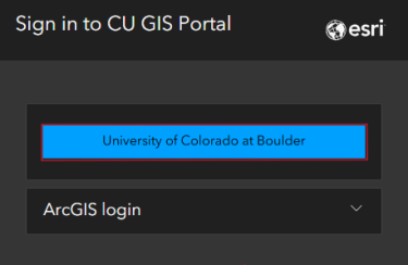
At login, please select 'University of Colorado at Boulder' to login with your identikey:
The SIM lives on our CU GIS Portal which has other map based resources available (links below):
UCB Space Information Map (SIM)
CU GIS Portal
Using the Space Information Map
We have user instructions and frequently asked questions (FAQs) that link to specific sections of them available, and be aware that you will need to use your CU Google account to access them:
Using the Space Information Map
Space Information Map FAQs
The main campus stakeholders who have access to this resource are as follows:
- Infrastructure & Resilience (I&R) employees at CU Boulder
- Building proctor or managers at CU Boulder
- Space coordinators for organizations on campus, those who assist with campus space surveys and/or space related decisions for their unit
- There are other use cases for this resource, so please contact us to request access or learn more