Gravel Epic - 53.1 Miles
Gravel Epic Route Update
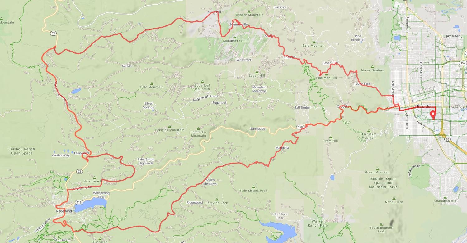
This year, the official Gravel Epic route will use the Gold Hill option instead of the Switzerland Trail option offered in previous years.
We selected Gold Hill because it provides a scenic and enjoyable gravel riding experience that is better suited to most gravel bikes. Riders will continue on the Peak to Peak Highway after leaving Nederland and follow Gold Hill Road, with route markings provided along the course.
We look forward to sharing this beautiful route with you on ride day!
Gravel Epic Ride Overview
Choose your adventure: 53.1 miles
Start time: 7:00 a.m.
Start location: CU Boulder Campus, Benson Field
Fun Fact on Canyon Closure: Boulder Canyon is closed to westbound vehicle traffic only once a year - for this event! The Canyon will be closed from 7:00 a.m. – 9:00 a.m. on the day of the ride
Route Summary:
Buffalo Bicycle Classic's Gravel Epic is the ultimate mix - you get to ride up the canyon and enjoy some of the county's best mountain gravel.
The Gravel Epic Route
The route begins at the CU campus at 7am with a peloton lead out down Folsom to Arapahoe to 6th Street to Canyon Blvd. The Boulder Canyon section is be closed to uphill vehicle traffic until you turn left turn onto Magnolia Road near mile 6. The beginning of Magnolia Rd. is very steep, averaging over 9% for the first few miles, with some sections nearing 20%. It's tough but totally worth it! Your bicycle will need good climbing gears. The first aid station is near mile 20 in Nederland at Tin Shed Sports.
After Aid Station #1 in Nederland, the route continues further up the Peak to Peak highway to Gold Hill Road (gravel). There is a second aid station where the Switzerland Trail meets Gold Hill Road, then you will continue on to the town of Gold Hill on gravel.
- Distance: 53.1 miles (25 miles gravel)
- Elevation Gain: 6,583 ft
- Highlights:
- Boulder Canyon: Closed to uphill traffic until Magnolia Road (mile 6)
- Magnolia Road: Steep climb (avg. 9%, up to 20%) — bring climbing gears!
- Gravel Section: Miles 11–18 — Magnolia Road
- Aid Station #1: Tin Shed Sports, Nederland (mile 20)
- Scenic ride along Peak to Peak Highway
- Buff gravel along Gold Hill Road
- Aid Station #2 at Mile 43 (Switzerland Trail & Gold Hill Rd)
- Gravel to the town of Gold Hill
Final Descent
The route finishes with the same thrilling descent back into Boulder. From Gold Hill, you'll take Gold Hill Road toward the town of Salina, then down Four Mile Canyon, up Poorman Road, and down Sunshine Canyon. Once back in Boulder, riders return to campus via 4th Street, Pearl Street, 6th Street, Arapahoe Avenue to Folsom Ave. and back to Benson Field on the CU Boulder campus.
— it's going to be EPIC!
Gravel Epic Route Map and Download