
Atlantic Seasonal Hurricane Prediction
The figure above shows the climatological distribution of outgoing longwave radiation (OLR) during July, 1979-2015, from the NOAA Interpolated OLR data set. Superimposed on the map are all tropical cyclone tracks from 1979-2014 from the HURDAT2 data set.
Background
In 2006, I published the first paper of my career, in Geophysical Research Letters, proposing that the spatial pattern of outgoing longwave radiation (OLR) over the African continent is mechanistically linked to the level of activity in a given Atlantic hurricane season, and that this relationship holds untapped potential for seasonal predictability (Karnauskas 2006). A decade later, I noticed this relationship has held up rather well. The time had thus come to return to this idea, improve the algorithm, and turn it into a real-time seasonal forecast system by leveraging another decade's worth of observations (satellite data, hurricane statistics, etc.)—not to mention the new tools, techniques, and (hopefully) some analytic intuition I've picked up along the way.
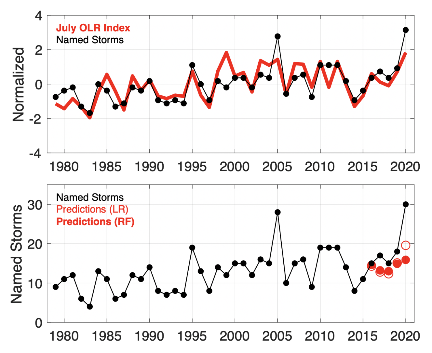
The methods behind the latest effort to do so are described in Karnauskas and Li (2016). As in Karnauskas (2006), the prediction algorithm is relatively simple and easy to compute, relying solely on satellite-derived OLR. Over the period 1979-2020, the July OLR index correlates very highly (r=0.77) with the total seasonal number of named storms (figure below). For the period 2001-2015, hindcast predictions based on the July OLR field and trained only on the time period prior to the year being predicted yielded a success rate of 87% with an average uncertainty of ± 2 storms. Although real-time predictions have only been conducted and validated for five years now (2016-2020), the correlation between those real-time predictions published at the beginning of June (August) have a correlation with the total seasonal number of named storms of 0.91 (0.94).
The official Atlantic hurricane season spans June through November. Official NOAA outlooks including predictions of the number of named storms to occur in the upcoming/ongoing season are issued in late May and early August. Predictions based solely on satellite observations of OLR made throughout the months of May and July, as developed in Karnauskas and Li (2016), will be published here on roughly the same schedule. Additionally, predictions based on June OLR data may be published at the beginning of July.
Relevant papers, resources, and code may be found below. Seasonal predictions issued each year by the algorithm developed in Karnauskas and Li (2016) and by NOAA will appear in the submenu to the right.
Papers
Karnauskas, K. B., 2006: The African meridional OLR contrast as a diagnostic for Atlantic tropical cyclone activity and implications for predictability. Geophys. Res. Lett., 33(6), L06809, doi: 10.1029/2005GL024865.
Karnauskas, K. B., and L. Li, 2016: Predicting Atlantic seasonal hurricane activity using outgoing longwave radiation over Africa. Geophys. Res. Lett., 43(13), 7152–7159, doi: 10.1002/2016GL069792.
Resources
NOAA OLR: http://www.esrl.noaa.gov/psd/data/gridded/
Historical tropical storm data: http://www.nhc.noaa.gov/data/#tracks_all and http://www.nhc.noaa.gov/data/#hurdat
Current and archived NOAA NHC outlooks: http://www.cpc.ncep.noaa.gov/products/outlooks/hurricane-archive.shtml
Code
MATLAB code and supporting data files necessary for reproducing all analyses and figures in Karnauskas and Li (2016), as well as most from Karnauskas (2006). Download from this Dropbox link, unzip, and start with the file called Karnauskas_Li_2016_GRL_Paper_Code.m
Just the MATLAB code and supporting data files necessary to run the seasonal prediction routine of Karnauskas and Li (2016). Download from this Drobox link, unzip, and start with the file called Karnauskas_Li_2016_GRL_Predict_Code.m