
What a Long, Strange Trip It’s Been
The department was and continues to be supportive of my intention to create a world-class GIS program. I began to develop and teach GIS, Cartography and Information Design, Cartographic Animation, and GIS modeling. The campus computing center (then called Information and Technology Services, or ITS) was opposed to supporting any software that could not find wide use in every computer lab on campus, in spite of our classes enrolling students from all across campus. ITS informed me in 1997 they would cancel the ARC/INFO site license because it was “too costly”, even though they were charging $395 per seat and using those funds to pay for the campus site license. At that time, a working knowledge of ESRI software was a basic qualification for any student entering the GIS job market, so without the license, our fledgling curriculum would cease to provide marketable skills to students. I contacted the GIS professors Lynn Johnston (CU Denver Civil Engineering) and John Harner (CU Colorado Springs Geography), and the three of us negotiated with ESRI for a joint CU system-wide site license at a reduced cost for all three campuses. In following years, the use of ESRI software increased so fast across campus that the cost per seat dropped steadily and today is free to all campus users, including students, faculty, College technology services such as ASSETT, campus planning offices and FACMAN, who have hired several graduates directly from our program.
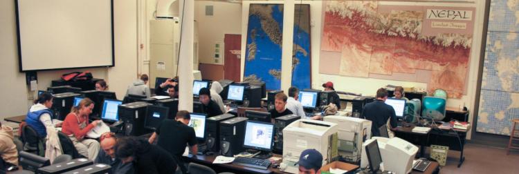
Ken Erickson Spatial Data Analysis lab (KESDA) in 2004. Named in 1996 for the CU Geography professor who published research on conservation and who taught cartography for 28 years. Photo by Jim Robb.

KESDA in 2020. Photo by Jeff Nicholson.
Over time, the department has added three tenure-track faculty lines and a full-time instructor to the curriculum. Course emphasis has shifted from teaching just the basic use of commercial software to emphasizing Python programming and production of open-source software tools on Jupyter and similar platforms. The curriculum now spans a dozen regularly offered courses in GIS Quantitative Methods and Spatial Analysis, with more currently under development. We regularly place students completing degrees at software companies such as MAXAR (formerly DigitalGlobe), ESRI, SUN Microsystems; at federal, state and local agencies; and in research and faculty positions at other universities. The department has a vital internship program and roughly 2/3 of the positions offered in any year request GIS and geospatial analytic skills. We receive applications from all over the world from highly qualified students wishing to pursue graduate work. GIS and geospatial data science methods are utilized by many faculty and students studying geographic applications in climate change, fire science, population growth, hydrology, biogeography, habitat degradation, war and conflict, and public health. Our GIS faculty are working to develop new tools and advanced methods to support uncertainty assessment, to build multi-scale databases, and to integrate data over space and time.
Looking back, it’s taken a quarter of a century to establish a vital curriculum. That may seem a long time, but not to anyone who has built a university-level curriculum from an essentially blank slate. Importantly, I could not have accomplished this alone. Along the way, a few valued GIS colleagues left the program, and equally valued new colleagues joined. Without the help of all of these people, the curriculum would not be, indeed could not be what it is today. As I retire at the end of this year, I am leaving much unfinished, and that’s the best way to foster future growth and advance. I hope that I have catalyzed a critical momentum that will carry our GIS program forward in productive and likely unforeseen ways in coming years.
Also see the news item in this newsletter about Babs receiving the American Association of Geographers (AAG) Distinguished Teaching honors for her career-long devotion to GIScience education. -- Editor
Department logo with a nod to the GIS curriculum Babs developed.