
India and Pakistan once again step back from the brink
CU Boulder historian Lucy Chester notes that the recent tensions between the two nations, incited by the April 22 terrorist attack in Kashmir, are the latest in an ongoing cycle
When a gunman opened fire April 22 on domestic tourists in Pahalgam, a scenic Himalayan hill station in Indian-administered Kashmir, killing 26 people, the attack ignited days of deadly drone attacks, airstrikes and shelling between India and Pakistan that escalated to a perilous brink last weekend.
A U.S.-brokered ceasefire Saturday evening diffused the mounting violence between the two nuclear-armed nations that increasingly seemed on a trajectory toward war. It was the latest in a string of escalations spanning many decades between India and Pakistan, which invariably led to the question: Why does this keep happening?

CU Boulder historian Lucy Chester notes that the recent conflict between India and Pakistan is part of a broader history that includes not only religion, but water, maps and territorial integrity.
Lucy Chester, an associate professor in the University of Colorado Boulder Department of History and the International Affairs Program, has studied the region and relations between the two nations for many years; her first book, Borders and Conflict in South Asia, explores the drawing of the boundary between India and Pakistan in 1947.
Despite President Donald Trump’s assertion that the origins of the conflict date back a thousand years, “that’s not the case,” Chester says. “I would say it’s mainly about Kashmir, with some additional issues at play this time around that changed the dynamics a bit.”
When more than a century of British colonial rule of India ended in August 1947, the Indian subcontinent was divided into Hindu-majority India and Muslim-majority Pakistan—a bloody, devastating event known as Partition. An estimated 15 million people were displaced and an estimated 1 to 2 million died as a result of violence, hunger, suicide or disease.
The first Indo-Pakistani war ignited two months after Partition, in October 1947, over the newly formed Pakistan’s fear that the Hindu maharaja of the princely state of Kashmir and Jammu would align with India. The Indo-Pakistani wars of 1965 and 1971 and the the Kargil War of 1999 followed, as well as other conflicts, standoffs and skirmishes.
Chester addressed these and other issues in a recent conversation with Colorado Arts and Sciences Magazine.
Question: These decades of conflict are often framed as Hindu-Muslim conflict; is that not the case?
Chester: There’s an older dynamic of Hindu-Muslim tension that definitely plays a role in this, but a significant aspect of the conflict over Kashmir is a conflict over water, which is really important. It has to do specifically with Kashmir’s geopolitical position and how a lot of the water that is important to India, that flows through India into Pakistan, originates in Kashmir.
It was a lot about popular pressure this time—Hindu nationalist pressure—on (Indian Prime Minister Narendra) Modi, which is a dynamic that he has very much contributed to. So, in that sense, it could be framed as Hindu-Muslim tension.
But it’s also about territorial integrity—that’s a phrase that kept coming up—and it’s a very loaded phrase that does go back to 1947 and the kinds of nations that India and Pakistan were conceived of in the 1940s and the kinds of national concerns they’ve developed in the years since.
Question: What role did Hindu nationalism, which has been very much in the news since Modi’s re-election last year, play in this recent conflict?
Chester: Hindu nationalism has been important in South Asia since the late 19th century, certainly, and it’s become more important since the 1930s. It’s one strand of the larger Indian nationalist movement—Indian nationalism was behind the assassination of Mahatma Gandhi in 1948. So, it’s always been there, but Modi, of course, has really ramped it up. For a while he distanced himself from the BJP (the Bharatiya Janata Party political party associated with Hindu nationalism), but he’s since made it very clear that he is very much in line with Hindu nationalist ideals and played on those symbols and those dynamics centered to what Hindu nationalist voters wanted.
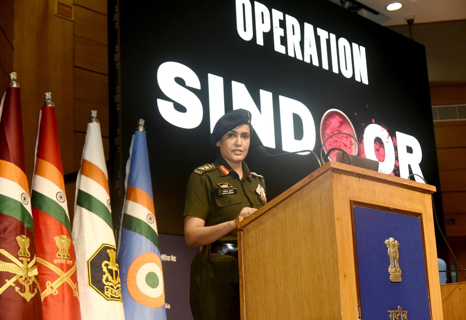
Colonel Sofiya Qureshi addresses the media about Operation Sindoor at the National Media Centre in New Delhi May 7, 2025. (Photo: Government of India Ministry of Defence)
This whole idea of Hinduness gets back to the various ways both India and Pakistan are conceived of as nations. Hindutva (a political ideology justifying a Hindu hegemony in India) conceives India as a fundamentally Hindu nation, and that idea has gotten so much more reinforcement from Modi and the national government over last 10 years. So, part of what happened with this awful terrorist massacre two weeks ago is that it created a lot of pressure on Modi to respond in a way that previous Indian administrations haven’t felt they had to respond.
Question: In the recent conflict, India accused Pakistan of perpetrating the attack, which Pakistan denied, and framed the response as a defense of ‘Mother India.’ What does that mean?
Chester: Sumathi Ramaswamy explained it best in her book (The Goddess and the Nation: Mapping Mother India), where she talks about Mother India as this cartographed divine female figure who’s very much identified with the cartographic body of the nation. So, any attack on the territorial integrity (of India) is an attack on this woman, this mother figure.
The (recent) Indian Operation was called Operation Sindoor—sindoor is the red coloring that married Hindu woman put in the part of their hair—a call-out to this idea of Mother India and a call to the nation’s sons to be willing to die for her or to kill for her in this case.
In 1947, with the Partition of British India into India and Pakistan, the conception for many in India was a really tragic carving up of the body of the nation, and for a number of Hindu nationalists, that was a specifically female body. For a lot of people in India to this day, the 1947 Partition is this massive failure and an amputation of key elements of the national body. On the other side in Pakistan, for many it’s this great narrative of victory, but on the Indian side there’s this recurring existential fear that further parts of the country could be carved off this way. I think a big part of why conflict keeps happening is that both sides feel very strongly about defending the national territory because it was torn apart in such a violent way, and I think that fear is just most vividly present in Kashmir.
Question: How does the history of Kashmir in terms of British rule and Partition come into play?
Chester: In terms of British India, there were areas that were directly ruled and areas that were indirectly ruled. The indirectly ruled areas were princely ruled, and this is important because Kashmir was a princely state with a Hindu maharaja and a majority-Muslim population. With princely states, in theory they could decide for themselves whether to accede to India or Pakistan, and the maharaja of Kashmir, most would say he was angling for some kind of autonomy or independence and delayed the decision on whether to accede to India or Pakistan.
In October of 1947, militia groups—almost certainly supported by Pakistan—invaded Kashmir and the maharaja appealed to India for help. India airlifted troops in, because there was no all-weather road efficient for deploying troops, which gives you a sense for both how remote Kashmir was and parts of it still are, and also that there weren’t a lot of infrastructure connections.
So, the first Indo-Pakistan war was in 1947 to 1948, then a second war in 1965 and a third in 1971. This reinforces that fear of the country fragmenting and losing parts of the national body, because it was after the 1971 war that Bangladesh became independent (from Pakistan).
In 1949, India and Pakistan established a Ceasefire Line that became the Line of Control in 1972 with the Simla Agreement. The Line of Control is significant because it’s treated as an international boundary—not de jure (existing by law or officially recognized), but de facto. In 1972, officials came up with a textual description for the Line of Control and they define it up to NJ9842, which is the northernmost point on the map where it ends. The text of treaty says something like, “Proceed thence north to the glaciers.” This territory is so remote, so geopolitically useless, that no one at the time thought spending time to define where boundary line ran was important.
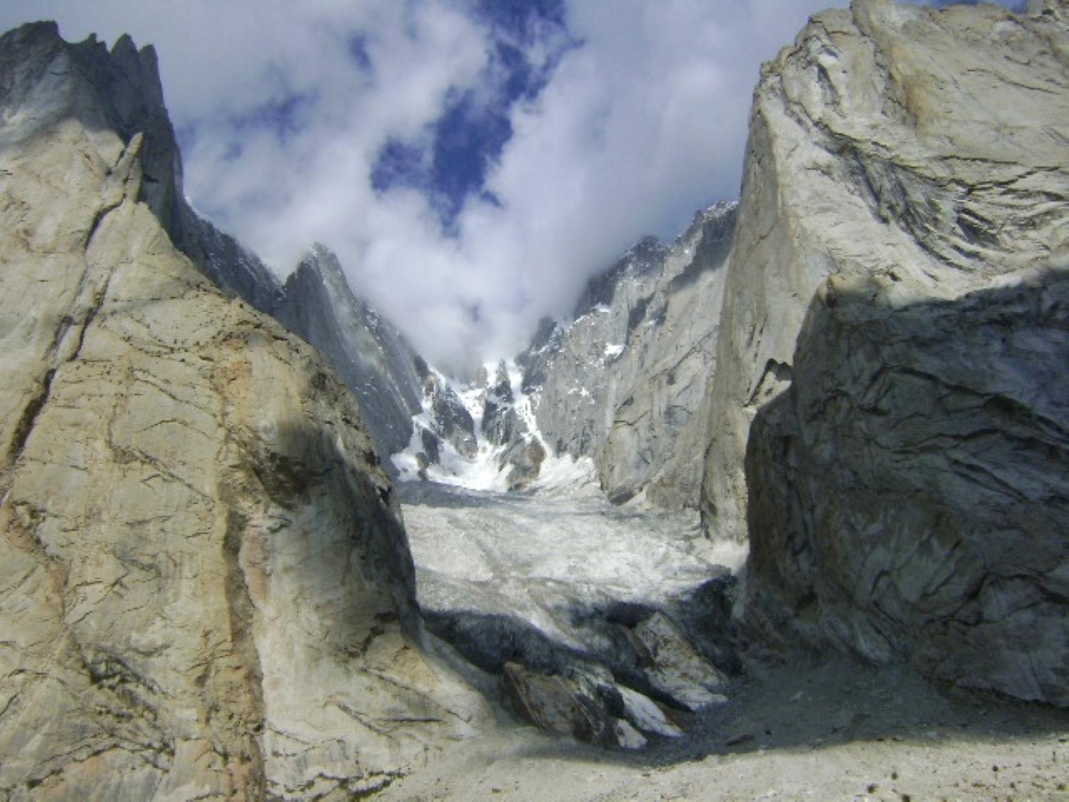
In the mid-1980s, both India and Pakistan sent troops to the Siachen Glacier, creating one of the highest more-or-less permanent military bases at about 22,000 feet. (Photo: Wikimedia Commons)
So, north of NJ9842 is this really undefined area—you’ve got Pakistan-controlled territory, India-controlled territory, China is right there, the Karakoram Pass is right there. What happened in the late 1970s, and possibly earlier even into the late 1960s, was Pakistan began issuing permits to international climbing expeditions, and in the early 1980s Indian troops discovered evidence of these international climbing expeditions. India realized that Pakistan had been exercising a certain form of administrative control over this undefined territory, and that’s what triggered the mid-1980s sending of troops from India and Pakistan to the Siachen Glacier. It includes what I think is the highest more-or-less permanent military base at something like 22,000 feet.
As a map geek, I find it really interesting that maps have contributed in pretty direct ways to these conflicts. One of the really tragic elements is that we know that on the Indian side, 97% of conflict casualties in that area are due to terrain and weather, and we can assume similar numbers on the Pakistani side. You’ve got these two countries fighting this battle, but they’re also fighting Mother Nature. In fact, the 1999 Kargil War happened because Pakistan tried to move some of its troops to a higher altitude where they could overlook an Indian road that supplied these high-altitude posts.
Question: What role did water play in the recent conflict?
Chester: All of the water that feeds the rivers that run downstream into western India and Pakistan originates in that region, which gives it real geopolitical value. One of the things that had me particularly concerned this time was India suspended the Indus Waters Treaty from 1960, which was a really landmark agreement governing the sharing of these waters. Some of these rivers flow through India before they get to Pakistan, and at this point India doesn’t have the infrastructure to turn off the water. But Pakistan has said if India starts building that infrastructure, they will consider it an act of war.
Question: Is there anything that makes you feel even slightly hopeful amid these ongoing tensions?
Chester: Over the last two weeks, both sides have been very carefully walking this fine line between being very visibly seen to acknowledge popular pressure on them to stand up strongly to their adversary, but also making very carefully planned choices that as far as possible avoided uncontrollable escalation. Everyone is keenly aware these are both nuclear-armed powers. I was very concerned that it escalated as much as it did on both sides, particularly in the use of airstrikes, but I think both sides were doing their best to leave themselves and their adversaries an off-ramp.
Part of the significance of (the Kargil War in) 1999 was both sides had just come out of the nuclear closet, so everyone was watching that conflict very closely, but both sides were able to walk back from edge. That gives us a lot of reason to hope and to believe that there are very professional people on both sides—in addition to people who are whipping up popular frenzy—who have a good sense for what the limits are, what signals they can send, and who are saying to the population, “We listen to you, we respect your grievances,” but they also know where the edge is and aren’t crossing it.
Did you enjoy this article? Subscribe to our newsletter. Passionate about history? Show your support.