
Joel Gombiner - Project Profile
PhD candidate, University of Washington, during AGeS project
Age of ancient Moses Coulee megafloods with U-series dating on a gravel-capping calcrete
Some of the largest floods in earth history drained through the Columbia River during Pleistocene glacial periods (Baker, 2009). These events are known as the Missoula Floods or the Scabland Floods.
The most recent epoch of flooding lasted from ~20 to ~15 ka BP, and occurred when the Cordilleran Ice Sheet (CIS) was near its maximum extent. At this time, the Okanogan Lobe and Purcell Trench Lobe blocked the Columbia River, forming glacial lakes Columbia and Missoula. Glacial Lake Missoula was metastable and its ice dam released episodic megafloods, whereas glacial Lake Columbia was stable and did not drain through its ice dam.
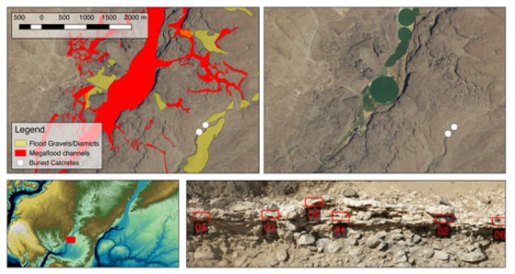
The erosive power of the Missoula Floods incised the Channeled Scabland drainage system into the Columbia Plateau. During floods, water spilled over the banks of the Columbia River and flowed southward across the Columbia Basin. Spill-over along the south bank of the Columbia and into the Channeled Scabland occurred primarily when the Okanogan Lobe of the Cordilleran Ice Sheet blocked the river between the Omak and Waterville Plateaus. Additionally, even when the Columbia River was not impounded by the Okanogan Lobe, drainages from Lake Missoula may have been so large and sudden that water filled the river channel and spilled southward into the Channeled Scabland (Denlinger et al., 2021). Four main spill-over points created four drainage systems: Moses Coulee, Grand Coulee, Telford-Crab Creek, and Cheney-Palouse. This study focused on Moses Coulee.
Both terrestrial and marine sediments suggest Missoula Floods also occurred prior to the well-documented last-glacial episode of flooding. Luminescence dating of loess interpreted to overlie flood deposits and flood-cut unconformities suggests the penultimate episode of flooding occurred prior to the initiation of loess deposition at 58-74 ka BP during Marine Isotope Stage 4 (Berger and Busacca, 1995; Richardson et al., 1997; McDonald et al., 2012). Uranium series ages on calcified megaflood gravels in eastern Washington range from 92 to >400 ka, and paleomagnetic data suggest that other megaflood gravels may be as old as early Pleistocene (Bjornstad, 2001; Bader et al., 2016). In the marine realm, the neodymium, hafnium, and lead isotopic composition of Astoria Fan sediments have been explained as evidence of the Missoula Floods transporting cratonic material from western Montana into the Astoria Fan during Missoula Floods that occurred throughout the last 2.5 million years (Prytulak et al., 2006).
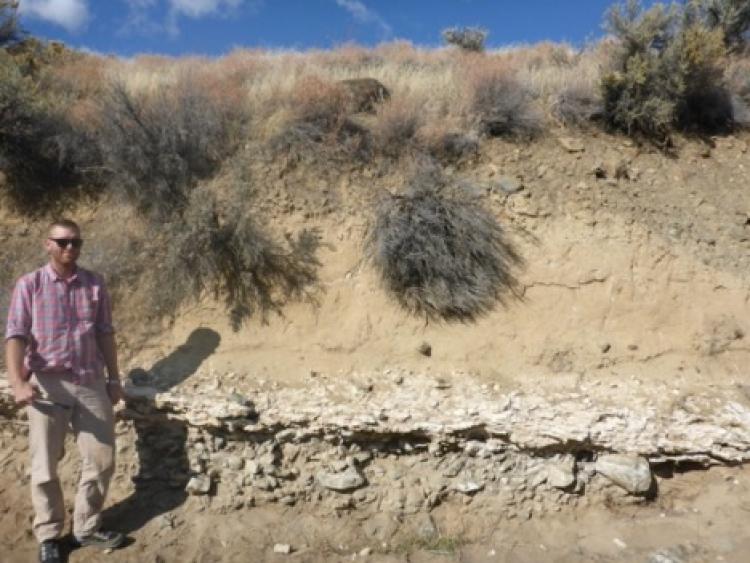
In this pilot study, we attempted to build on previous U/Th geochronology to investigate the history of ancient megafloods in the Channeled Scabland. We focused on a gravel deposit in Moses Coulee that is cemented with calcrete. The calcrete layer formed on the gravel, so the gravel is even older than the calcrete. The scoured bedrock surface on which the gravel rests is even older. The sedimentology of the gravel suggests that it was deposited in a megaflood, rather than from a flash or seasonal flood in the ephemeral stream in which it is exposed.
The calcrete layer appears too thick to have formed in the last 15,000 years, and therefore appears to date a pre-last glacial episode of Moses Coulee megafloods.
We applied the U-series dating method to this calcrete layer. I worked with undergraduates from University of Washington to sample the deposit in the field, and then drilled out powders at University of Washington. Due to the pandemic, I was unable to travel to MIT to complete the dating work. David McGee and Adam Jost at MIT prepared and ran the samples for me.
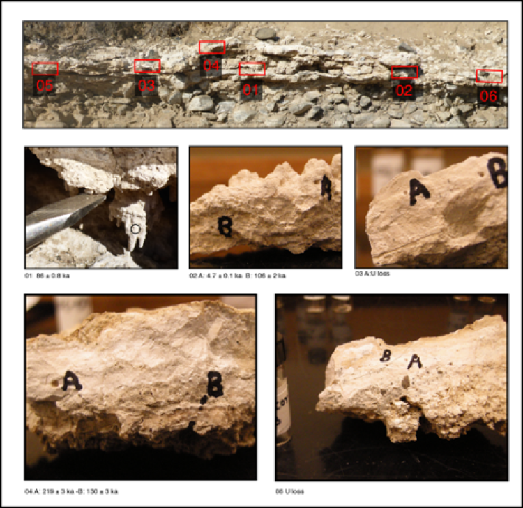
The 230Th/238U activity ratios from the samples indicate that Uranium loss has occurred in some samples. Uranium loss biases radiometric ages old by preferentially removing the parent isotope, so it is a problem for dating.
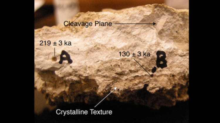
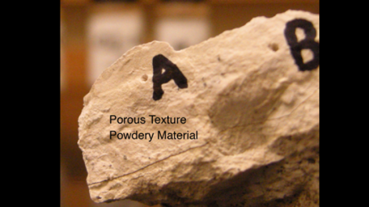
However, the samples with obvious uranium loss appear to have different textures than the samples without obvious uranium loss. The samples which exhibit uranium loss have textures that are porous and powdery. These textures and the loss of uranium are the result of ground-water leaching the calcrete over time and removing uranium. However, samples with denser, crystalline textures do not have obvious evidence of uranium loss. The nominal ages for these “good” samples range from 219,000 ± 3,000 years to 86,000 ± 800 years. We remain uncertain about whether these are “real” ages, or whether they are biased old by uranium loss. Future plans include radiocarbon dating to confirm that the samples are indeed older than the last glacial, and repeat U-series measurements from a single layer within a single hand sample to test for reproducibility.