
Erin Peck - Project Profile
PhD Candidate, Oregon State University, during AGeS project
Dating During the Pandemic: A Radiocarbon Success Story
Intertidal accommodation space filling following the 1700 Cascadia Subduction Zone Earthquake

The Cascadia Subduction Zone, which spans from British Columbia to Northern California, periodically experiences megathrust earthquakes M >8. During these ruptures, the last of which occurred in 1700, areas of the coast experience co-seismic subsidence of up to 3 m. This subsidence results in instantaneous sea level rise, the creation of accommodation space (i.e., volume below sea level that may be filled with sediment), and destructive tsunami that may simultaneously erode coastal areas and/or emplace a sandy deposit. These earthquake and tsunami deposits are well preserved in estuarine stratigraphy along the Pacific Northwest coast (as Illustrated in Image 1). Much research has rightfully focused on predicting recurrence intervals, magnitudes, co-seismic subsidence rates, tsunami inundation, and landslide hazards. Yet there remains uncertainty related to the long-term impacts of earthquakes on coastal habitats – namely the timeframe of accommodation space filling following the co-seismic subsidence. We know that accommodation space fills and salt marshes grow back following earthquakes, but does it take less than a decade? Much longer, up to 150 years?
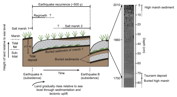
This is an important question to answer for a number of reasons. From a hazards perspective, our understanding of earthquake recurrence stems, at least in part, from statistics related to the number and timing of earthquake/tsunami deposits recorded in coastal stratigraphy. These deposits can only be preserved and identified if the proceeding earthquake occurs after the salt marsh has been reestablished. Thus, if accommodation space filling requires many decades to centuries, it is possibly that intermediate earthquakes may have occurred but went unrecorded. From a biogeochemical perspective, intertidal areas are located along the sediment routing system in a unique position – either functioning as a sediment sink or source to the coastal ocean depending on the regime. Thus, whether these habitats are accumulating, bypassing, or eroding sediment influences marine sediment sinks and records, and coastal biogeochemical cycling and productivity. From an ecogeomorphic perspective, understanding the rate and mechanisms of salt marsh reestablishment will better inform how these systems respond to large perturbation events beyond just earthquakes (e.g., storms, sea level rise, wildfire, landslides), and thus may improve our ability to predict how they will evolve into the future. From a social perspective, salt marshes provide a number of culturally and economically important ecosystem services including flood protection, habitat, and carbon burial. The next major Cascadia Subduction Zone earthquake will undoubtedly occur during a period of accelerated sea level rise, increasing the possibility that these habitats and the services they provide may be lost for many decades to centuries.
Below - Image 2: CT scan of the Netarts sediment core chosen for analysis. Darker areas are less dense and whiter areas are more dense. The core was originally 3 m long but was cut in half for transportation and the half on the left is the upper section with a clear 1700 tsunami deposit (dense, sandy layer with a sharp contact with buried marsh below) at around 70 cm depth. More tsunami deposits from past earthquakes are visible throughout the core.
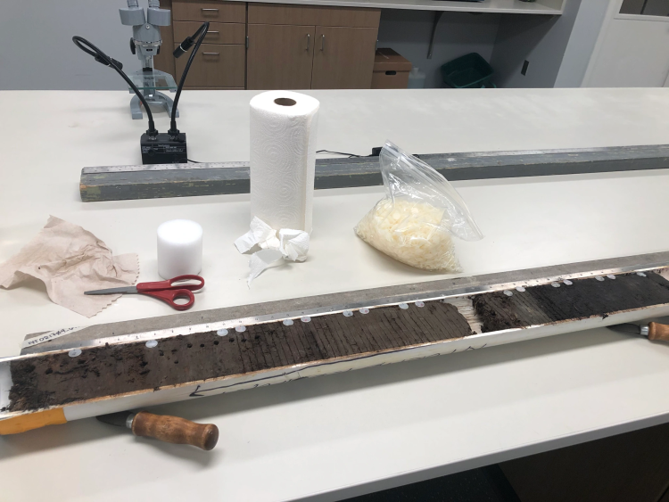
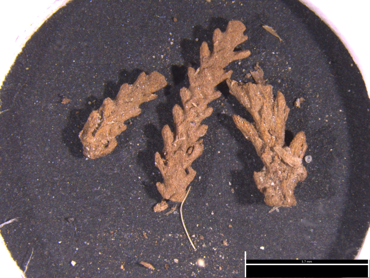
So why have we not yet determined the rate of accommodation space filling following the last major earthquake in 1700? It turns out that the last ~300 years is a notoriously tricky time period to date. A number of useful methods exist for the last ~150 years, the most commonly applied in salt marshes being excess 210Pb. Thus, my quest as an AGeS award recipient was to determine if I could combine excess 210Pb over the last ~150 years with 14C from ~150 to 300 years ago to date salt marsh sediment back to 1700. Unfortunately, it is during this time period that the production of 14C in the atmosphere conspires with the decay rate to make changes in 14C measurements insensitive. For instance, if we measure a radiocarbon age of 150 it could be calibrated to a window of almost 300 years. However, with the help of my mentor Tom Guilderson, we hypothesized that high-density 14C sampling combined with other dating techniques (excess 210Pb and the known date of the tsunami deposit) and Bayesian age-depth modeling could allow us to effectively wiggle match our chronology to the radiocarbon calibration curve and produce a highly accurate and precise age-depth model for the last 300 years. I decided it would be best to make these measurements in Netarts Bay, Oregon. I already have many sediment cores from Netarts with many clear earthquake/tsunami deposits (see Image 2), and Netarts is a relatively simple system only being ~34 km2 that is well characterized. So I chose a sediment core, split it open lengthwise (see Image 3), sampled it for macrofossils (see Image 4), processed these and sent them to Lawrence Livermore National Laboratory for radiocarbon analysis. I was unfortunately unable to analyze my radiocarbon samples myself because of travel restrictions during the COVID-19 pandemic.
And after many, many hours peering through a microscope, looking for macrofossils to date, and sifting through Bayesian age-depth models to optimize our input priors, we think our method may have worked!!! Our radiocarbon dates extend the whole chronology, typically have uncertainties of less than 20 years, and match well with the independent measures of accuracy. Hurray!
So how long does accommodation space filling take? In Netarts it may have taken even longer than we had originally hypothesized – up to 200 years. Based on the sediment accumulation rate history (assessed based on the age-depth model) and the down-core biogeochemistry, high marsh didn’t reestablish until the late 19th century. It is difficult to say how these results extend to other Pacific Northwest estuaries. On one hand, Netarts experienced the mildest co-seismic subsidence of any coastal area during the 1700 event so maybe 200 years is actually on the quick side. On the other hand, Netarts has a very limited fluvial sediment input so maybe its accommodation space filled relatively slowly because sediment was not available. This second scenario seems most likely because historical maps indicate that most salt marshes were fully established by the 1880s; however, more work is needed. And we know this work is possible thanks to the support I received from AGeS.
For more information on my other projects, check out my website: erinkpeck.com