Mapping 200 years of American development
New CU Boulder research provides ‘unprecedented’ opportunity to study history and evolution of human land-use and development in the United States
The U.S. population has grown 40-fold since 1800 and yet little is known about precisely how or why it’s grown the way it has. New research from the University of Colorado Boulder, though, provides the most comprehensive look yet.

Stefan Leyk. Top Photo is a map of midwestern cities, by Johannes Uhl.
This new research, out today in Science Advances, draws a detailed picture of how and why the United States formed the way it did, improving our understanding of the history and evolution of human land-use and development in this country, and offering new opportunities to understand the spatial distributions of past populations.
Building on previous work by lead author Stefan Leyk and Johannes Uhl, these new visuals and data also provide an unprecedented chance to study long-term processes that could have implications on our understanding of future risks like sea level rise and wildfires, as well as the rural-urban divide.
“I’m a very strong believer that we need to know more about the past, what we did in the past, how our landscape has evolved in the past, and what, specifically, it means when we look at the built environment, to better understand the past 100 or 200 years of urban development,” said Leyk, an associate professor of geography at CU Boulder.
“We’re trying to understand the history, understand the evolution, understand how this socio-environmental system actually works … Because there are so many different components to it.”
[video:https://youtu.be/rxlbxt4nFaY]
Between 1800 and 2015, the population of the contiguous United States grew from 5.3 million to 309 million. During that time, humans sprawled out across the continent but researchers’ understanding of that growth has been disjointed at best.
Historically, there have only been two ways to study the change and evolution of landscapes: population- and land-based methods. Population-based methods rely on census records, but the lack of consistency over time and detailed records before the mid-20th century means that this method is challenging and intensive for researchers. Land-based methods (which look at historical land-use or how the land was used), on the other hand, are often limited to a few decades, and are incomplete or inaccurate for specific characteristics of built-up land or for rural areas.
Together, these approaches create an uneven picture of how the United States developed, increasingly becoming muddier when you zoom in and use finer scales of time and space.
Which, according to Leyk, is a persistent problem that geospatial scientists across the globe are trying to fix.
For Leyk and colleagues, the solution to that problem for the United States came from an unlikely ally: Zillow.
They worked with the housing company to get permission to use its massive dataset, the Zillow Transaction and Assessment Dataset (ZTRAX), which contains more than 374 million data records covering every single property it has on record. The researchers, with the help of funding from the National Science Foundation and National Institute of Health, then used that to bring both land- and population-methods together to create a new, unique source: The Historical Settlement Data Compilation for the United States (HISDAC-US).

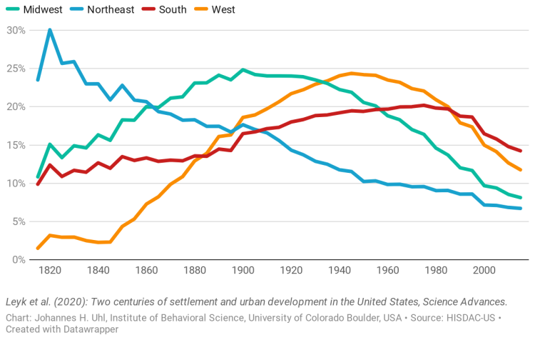
Relative expansion of built-up land in the U.S. since 1820
“It’s a big deal to bring these two perspectives together,” Leyk commented.
With this new settlement layer dataset, which is free for anyone to use and available on Harvard Dataverse, researchers mapped the built environment of the conterminous United States all the way back to 1810 at both fine temporal (five years) and spatial (250 meters) granularity.
Using these new data, researchers were not only able to see well-established land-use trends—such as urban development going westward over time or some areas building up before they joined the United States—they were also able to determine detailed growth patterns for human settlements, such as what factors may cause cities to expand or densify or how the growth of urban settlements compares to rural settlements.
For Leyk and his colleagues, though, this research is only a beginning. They are already using these historical data on several other projects—one such being better understanding the future threats that natural hazards may pose by looking at how we got here.
“It’s a big deal how we, as people in our built environments, are and have been exposed (to natural hazards) over long periods of time. We don’t know much about that, but the historical trajectories will tell us a lot about these changes, such as along the coastline.”
Other authors of the paper include Dylan S. Connor from Arizona State University; and Uhl, a former geography graduate student, Anna E. Braswell and Nathan Mietkiewicz, research scientists with Earth Lab, Jennifer K. Balch, director of Earth Lab and a geography professor, and Myron Gutmann, a history professor and the director of the Institute of Behavioral Sciences, from CU Boulder.

