
Dr. Adam N. Wlostowski: Mutually intelligible variations in hydrologic function across the Critical Zone Observatory network: A step towards understanding the hydrologic coevolution of the critical zone
The physical and biological architecture of the Earth’s Critical Zone controls hydrologic partitioning, storage, and chemical evolution of precipitated water. The Critical Zone Observatory (CZO) network is a consortium of field sites that provides an ideal platform to research linkages between catchment structure and hydrologic function across a gradient of geologic and climatic settings. A legacy of hypothesis-motivated research at each site has created an assemblage of data useful for characterizing the architecture and hydrologic function of the critical zone. We will present a synthesis of this data that aims to elucidate and explain (in the sense of making mutually intelligible) variations in hydrologic function across the CZO network. This research analyzes precipitation, streamflow, and meteorological data to extract top-down quantitative signatures of the storage and partitioning of water at catchment scales, which may be used as quantitative benchmarks to assess perceptual models of hydrologic function at each CZO site.
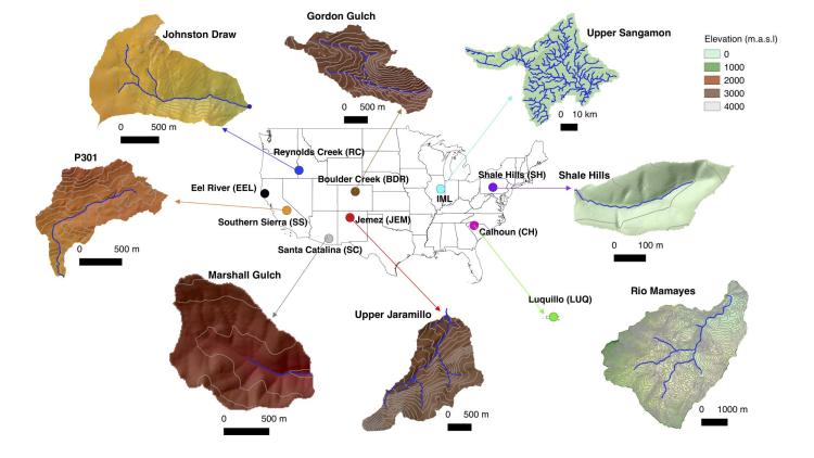
Annual water balance analyses show that CZO sites span a wide gradient of aridity and evaporative partitioning. The aridity index (PET/P) ranges from 0.3 at Luquillo to 4.3 at Reynolds Creek, while the evaporative index (E/P) ranges from 0.3 at Luquillo (Rio Mamayes) to 0.9 at Reynolds Creek (Johnston Draw). Snow depth and SWE observations reveal that snowpack is an important (albeit temporary) seasonal storage reservoir at three sites: Boulder, Jemez, Reynolds Creek and Southern Sierra, where snow can account for >50% of annual precipitation. Simple dynamical models are also used to infer seasonal patterns of subsurface catchment storage. A root-zone water balance model reveals unique seasonal variations in plant-available water storage across the CZO network. Seasonal patterns of plant-available storage are driven by the asynchronicity of seasonal precipitation and evaporation cycles. Streamflow recession curves are used to infer relative changes in hydraulic storage (the apparent storage reservoir responsible for modulating streamflow generation). Recession curves vary widely across the network and may be associated with inter-site differences in sub-surface architecture. Moving forward, we seek to reconcile top-down analysis results against the bottom-up understanding of critical zone structure and hydrologic function developed over a legacy research at each CZO site.
Dr. Adam N. Wlostowski
Postdoctoral Research Associate
Institute of Arctic and Alpine Research, University of Colorado Boulder