To Program for Writing and Rhetoric (WRTG) Teaching Associate Professor Rebecca Dickson, maps are an avenue for making a good argument. WRTG regularly partners with the Earth Sciences & Map Library to explore how maps can facilitate new ways of learning for first-year students.
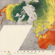
Buckminster Fuller, the creator of the Dymaxion Map Projection, spoke at the 1956 Conference on World Affairs. Then he gave CU Boulder a signed map. Learn about him and the humanitarian purpose of his famous map projection, in our World of Printed Maps series.
This month, we feature irrigation maps of the Boulder Valley from the 19th to the 21st centuries, ground water studies and historical aerial photography.
Highlighting a recent acquisition to our collections and honoring Louise E. Jefferson – a Black cartographer, artist, photographer, illustrator, calligrapher, and leader.
Thank you for visiting the University Libraries' website. Please fill out the form below to submit comments or questions about our buildings, services, website or any other topic.